Aboriginal Australians
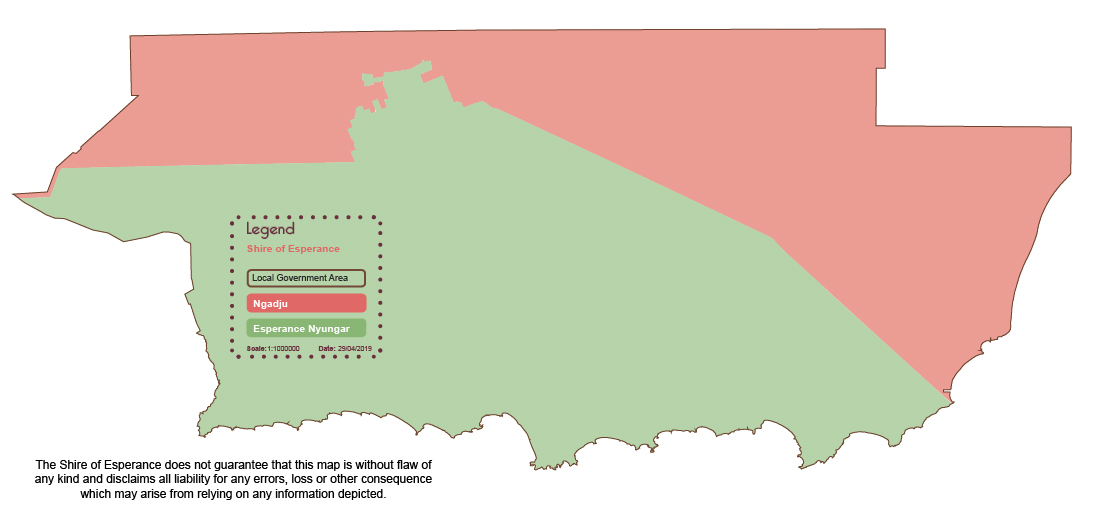
Aboriginal and Torres Strait Islander residents of the Esperance area make up 4.1% of the population of the Shire of Esperance. Their native title interests and cultural connections spread throughout the Shire of Esperance.
Strong traditional ties to land have created a significant range of native title claims and determinations within the Shire, including:
Esperance Nyungar
Esperance Nyungar Peoples' ancestral lands span over 30,000 square kilometres of Southern Western Australia.
Tjaltjraak comes from the Esperance Nyungar name for the Mallee (also known as Tallerack or Blue Mallee Eucalyptus pleurocarpa) which Esperance Nyungars believe mark the extent of their country.
Esperance Nyungar are descended from seven apical ancestors. Today, six family groups are recognised as the direct descendants of those ancestors and the elders of those families have the rights and responsibilities for the practice of Esperance Nyungar culture and for passing it on to future generations.
The six family groups are the Dabb, Boxer-Rogers, Reynolds, Yorkshire/Knapp, Bullen and Tucker. Today, the majority of Esperance Nyungar live within the Esperance region, though some live elsewhere in the southwest, including Perth, Albany and Norseman.
Esperance Tjaltjraak Native Title Aboriginal Corporation (ETNTAC) was registered by the Federal Court of Australia as the Native Title Body Corporate for the Esperance Nyungars on 6 September 2016. They are the first point of contact for government and other parties who want to conduct business with traditional owners in Esperance.
Ngadju
The Ngadju people have lived on country between Kalgoorlie and Esperance for perhaps as long as 50,000 years.
Like most tribal groups, the Ngadju people developed their own language and are proud of their important role as the carers and custodians of their land. Being spiritual people, they practiced sacred ceremonies and dances and many sites of significance remain important places for men and women to connect to country today.
The Ngadju people were known as the Song & Dance people and other tribal groups would approach them to help provide a new song or dance. The Ngadju elders only showed the visitors the song and dance routine once and then the visitors had to learn the routine and return home. The Ngadju people were, and still are, a very powerful and prominent people. They possessed the white flint rock which made a spark when struck together and Ngadju people carried the stones when travelling far and wide and would make a spark at night. After surrounding others and making the sparks it would bring enormous fear to whoever had done them wrong, for the people knew immediately who was present.
European Australias
Esperance Bay was named by the French navigator Antoine Raymond Joseph de Bruni d'Entrecasteaux in 1792 as his two ships took shelter near Observatory Island during a storm. Settlement did not occur until 1864 however, when the pioneering Dempster Brothers drove sheep, cattle and horses from Northam to establish the Esperance Bay Pastoral Station.
The town site of Esperance was Gazetted in 1893 after the discovery of gold in the Eastern Goldfields, and seemingly overnight, the little town experienced an incredible transformation as fortune seekers from all over Australia and around the world flooded the once sleepy little port on their way to the Goldfields.
In September of 1895, Esperance was declared a Municipality, however in the years following the district saw great population fluctuations as it endured the good times and the bad until the 1960's when the Esperance sand-plain began to emerge as a major agricultural region.
To discover more about the rich history of Esperance, visit the Esperance Museum or enjoy a read of our Local Heritage Survey - a comprehensive guide to local historic sites, exploration and settlement post European arrival in Australia.
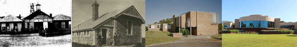
The Shire Administration Building through the years: 1896 - 1898 - 1965 - 1992
Shire of Esperance Native Title Map: